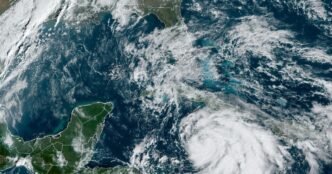

Tropical Storm Rafael is passing south of western Jamaica and is forecast to strengthen into a hurricane possibly by Tuesday evening.
Rafael, which formed Sunday and was previously known as Potential Tropical Cyclone 18, is located about 65 miles southwest of Montego Bay, Jamaica, with maximum sustained winds of 60 mph and moving north-west at 13 mph, according to the National Hurricane Center’s 10 a.m. ET Tuesday update.
Forecasters said Rafael is “getting better organized” as its center passes Jamaica. It’s expected to undergo “steady to rapid intensification” over the next 24 to 36 hours, and is expected to become a hurricane as it passes near the Cayman Islands this evening and tonight, the NHC said.
Rafael is the 17th named storm of the Atlantic hurricane season, and it will be the 11th hurricane if it strengthens further, as expected. The season lasts until Nov. 30, though peak activity is usually around Sept. 10.
The storm system is expected to approach the U.S. later in the week, the hurricane center said. A tropical storm watch was issued Monday afternoon for the lower and middle Florida Keys and for the Dry Tortugas, which was later upgraded Tuesday morning to a tropical storm warning.
It’s too soon to determine what, if any, impacts Rafael could bring to portions of the northern Gulf Coast, however, tropical storm winds are possible for the Florida Keys and south Florida on Wednesday afternoon. Rafael is also forecast to rapidly weaken as it is approaching landfall on the Gulf Coast.